CSG Midwest tracks the redistricting process and related developments in each of the 11 states of the Midwestern Legislative Conference.
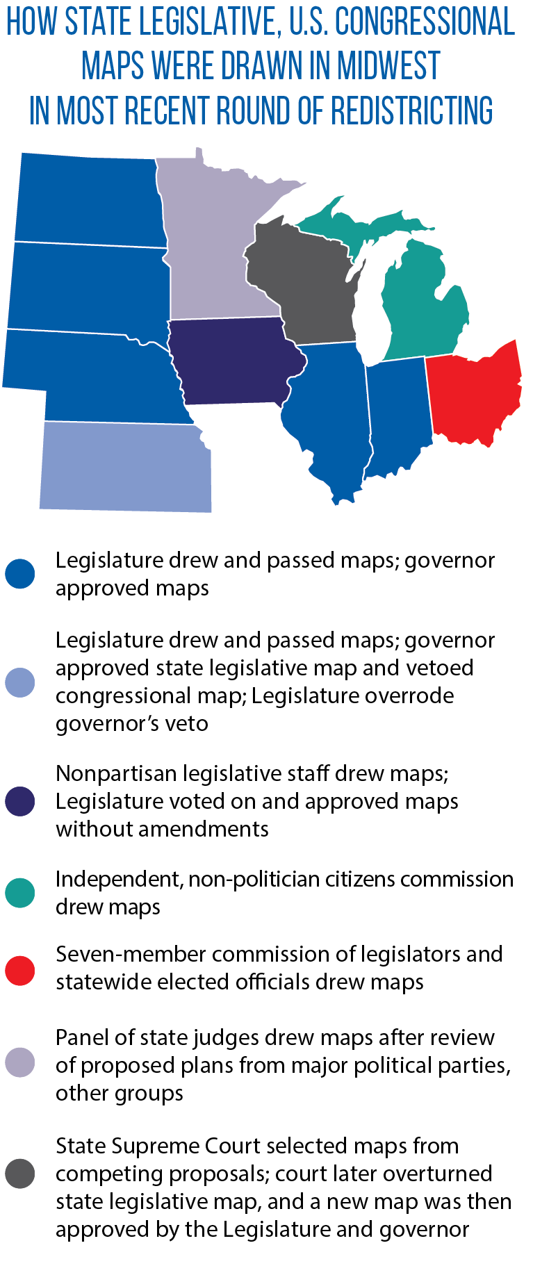
During the most recent redistricting cycle, it was most common for new congressional and state legislative district boundaries to be drawn and approved by the full state legislature, and then signed into law by the governor. This was the process used in Illinois, Indiana, Kansas (override of a gubernatorial in one instance), Nebraska, North Dakota and South Dakota.
However, there also was some notable variation this time around:
- Michigan’s first-ever use of an independent, non-politician redistricting commission;
- a drawing of the new maps by a panel of state judges in Minnesota;
- the use of a seven-member redistricting commission (made up of elected officials) in Ohio; and
- the significant role of the Wisconsin Supreme Court.
CSG Midwest first provided a regional roundup of redistricting in the summer of 2022. It most recently updated this page in February 2024 to include the impact of court rulings and/or legislative actions in Michigan, North Dakota and Wisconsin.
Illinois: Census delay, deadline caused drawing of two separate maps
The once-a-decade redistricting task in Illinois was unique this time around in at least one respect. When it came to new state legislative districts, the General Assembly developed and passed, and the governor signed into law, two plans in a single year.
This extra step was due to a delay in the release of official U.S. Census data, along with language in the Illinois Constitution stipulating that the General Assembly complete state legislative districting by June 30 in the year following the census.
If this deadline had been missed, a bipartisan, eight-member commission would have taken over the process. The General Assembly’s first map, passed in May 2021, was based on population estimates. Later that year, a three-member federal panel of judges ruled that the legislative districts were unconstitutionally malapportioned.
But even before this October 2021 decision, legislators had passed a second map based on official census data (released in August of that year). This map also faced a legal challenge, on the grounds that it diluted the votes of minority groups and should have included more legislative districts with majority Latino or Black voters.
However, the constitutionality of the General Assembly’s second state legislative map was upheld in late 2021.
“The voluminous evidence submitted by the parties overwhelmingly establishes that the Illinois mapmakers were motivated principally by partisan political considerations [not race],” the three-member panel of federal judges concluded. Partisan gerrymandering falls beyond the purview of federal courts, the judges noted.
The General Assembly had no similar constitutional deadline for drawing new U.S. congressional districts. It approved this map in October, having to account for the loss of one seat due to reapportionment.
Indiana: More ‘communities of interest’ kept together
Indiana ran into a deadline problem of its own with the delayed release of census numbers. Its redistricting statute calls for congressional districts to be approved prior to adjournment of the General Assembly’s first session following the census. If the task is not done by this time, redistricting duties are turned over to a five-member legislative commission.
The General Assembly was ready to adjourn in April 2021, but did not have the necessary redistricting data in hand. So lawmakers held off official adjournment until the fall, when they could return to the Capitol to approve new maps.
Republican leaders in the House and Senate say the new maps reflect their goal of keeping more “communities of interest” together — for example, 32 counties are now wholly contained within one state House district (up from 26 under the previous map); 65 are contained in one state Senate district (up from 49); and 84 of the state’s 92 counties are in a single congressional district.
As in Illinois, Indiana’s plan was criticized for unduly favoring the party in charge of the redistricting process (Democrats in Illinois, Republicans in Indiana).
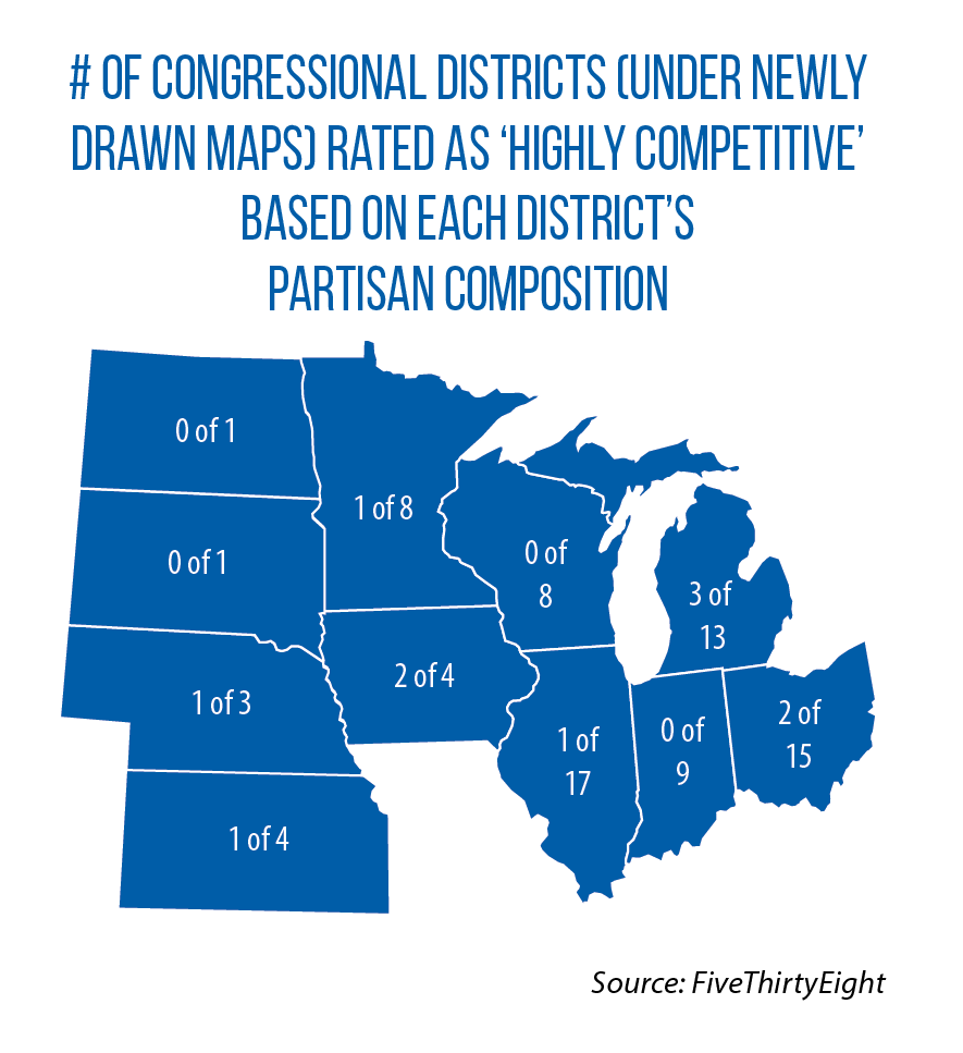
The partisan breakdown of Indiana’s delegation in the U.S. House is not expected to change with the new maps, however — seven Republicans, two Democrats, according to FiveThirtyEight.
Iowa: Nonpartisan staff draws maps; Legislature OKs with no changes
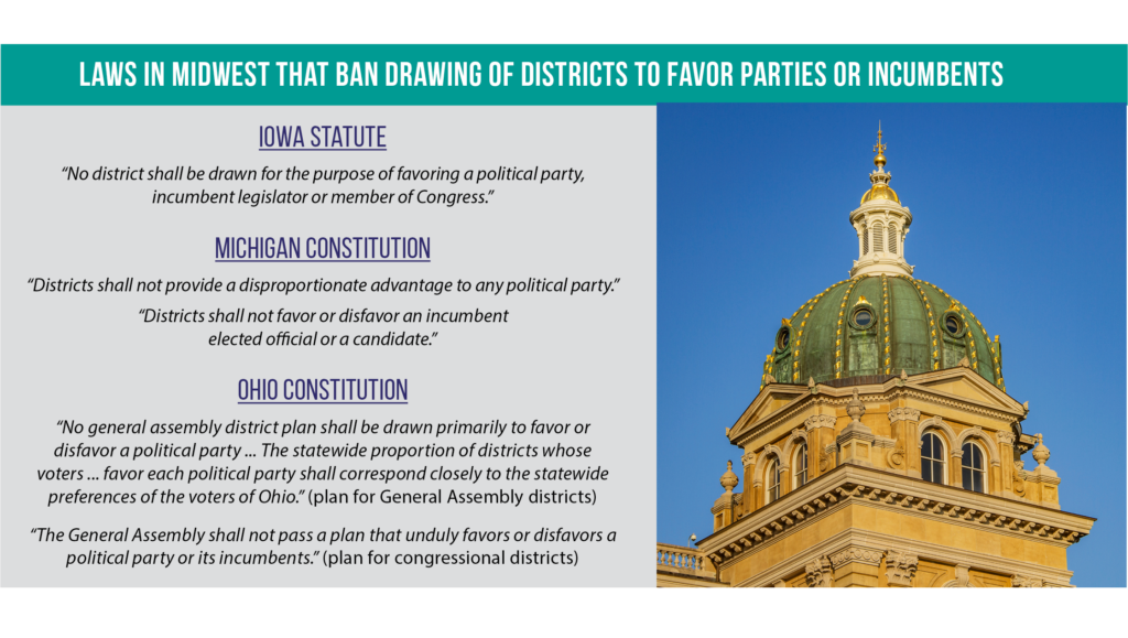
Iowa is one of three Midwestern states, along with Michigan and Ohio, that bans partisan gerrymandering. Since 1980, too, the nonpartisan Legislative Services Agency has steered the redistricting process, drawing new state legislative and congressional lines and presenting these maps to the full Legislature for an up-or-down vote.
If the LSA’s first plan is rejected, the agency prepares a second one for a legislative vote, again with no amendments allowed. Legislators can only make tweaks after the first two plans have been voted down and a third plan has been submitted.
Would Iowa’s approach hold during this round of redistricting, in a state where one party controls the legislature and governor’s office (Republican) and during a period of increased partisanship?
Yes.
During a special session in October 2021, legislators rejected a first LSA plan, citing concerns about the compactness of districts and population deviation. But later that same month, legislators gave near-unanimous approval to the second plan. Since Iowa first adopted a nonpartisan approach to redistricting, one of the LSA’s maps has always been approved without legislative amendment.
Kansas: Bipartisan support on one set of maps, override of veto on the other
A decade ago, the Kansas Legislature, though fully controlled by a single party (Republican), was not able to agree on new state legislative or congressional maps. As a result, a three-member panel of federal judges drew the political lines.
This time around, legislators reached enough consensus on both plans — getting the approval of Democratic Gov. Laura Kelly on the new state maps and overriding her veto of the congressional map. In March 2022, the Kansas House gave overwhelming approval to the state legislative maps, “a show of bipartisan unity” marked by “an ocean of backslapping, plaudits and more than one standing ovation,” The Topeka Capital-Journal reported. (One of the most controversial parts of the state maps turned out to be the new lines for State Board of Education, a move that caused some Democrats to oppose the final version.)
The Republican-led Legislature’s plan for Kansas’ four U.S. House seats was more controversial. Kelly criticized the new congressional lines for diluting the voting strength of minority communities and separating communities of interest — for example, carving Wyandotte County (part of the Kansas City area) into two congressional districts and placing parts of the city of Lawrence in a rural district.
The Kansas House and Senate quickly overrode her February 2022 veto, setting up a legal challenge based on claims of extreme partisan gerrymandering and racial discrimination. The Kansas Supreme Court, however, rejected these assertions. Race was not the predominant factor in drawing the districts, the justices concluded, and nothing in Kansas’ Constitution or statutes prevents partisan considerations in the redistricting process.
Michigan: Maps drawn for first time by independent commission
Michigan is the only state in the Midwest (and one of nine in the United States) that has put the redistricting process fully in the hands of an independent commission whose members cannot be legislators or other public officials.
This new process is the result of a constitutional amendment passed by voters in 2018. As part of this amendment, lobbyists, party officials, legislative staff and campaign workers are barred from serving on the commission.
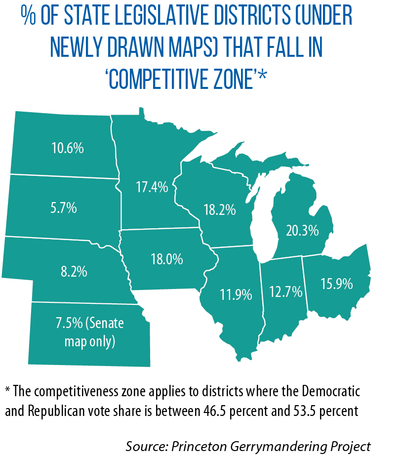
The commissioners — four affiliated with the Democratic Party, four with the Republican Party, and five with no major-party affiliation — completed the state’s new political maps in December 2021. Researchers at the Princeton Gerrymandering Project concluded that Michigan’s new redistricting process produced maps that were “fair” to both parties — a grade of “A” on partisan fairness for the state House and U.S. House maps, and a “B” for the state Senate map. (Project researchers noted a “slight advantage” for Democrats with the state House and Senate maps, and no advantage for either party with the new congressional lines.)
Still, legal challenges followed. The League of Women Voters of Michigan — citing the state’s new constitutional requirement that no political party get a “disproportionate advantage” — claimed the new maps favored the Republican Party. The Michigan Supreme Court dismissed the case, however, noting that partisan fairness also must be weighed against other criteria, such as keeping “communities of interest” together in a single district.
Separately, two racial-discrimination lawsuits were filed in state and federal courts. The Michigan Supreme Court upheld the new maps in a February 2022 decision. Plaintiffs in that case had argued that because the new redistricting plans reduced the number of majority-minority districts (as compared to the old maps), the result would be an unlawful dilution of minority votes.
In late 2023, a U.S. District Court ruled that elections could not be held in 13 Detroit-area state House and Senate districts without a fix to the lines drawn and approved by the Michigan Independent Citizens Redistricting Commission. Those districts were drawn predominantly on the basis of race, the court ruled, and the commission did not show that such racial gerrymandering was needed to meet a “compelling interest” such as compliance with the federal Voting Rights Act.
The U.S. Supreme Court chose not to intervene in the case. As a result, new maps needed to be approved and in place in time for the 2024 primary and general elections.
Minnesota: Panel of state judges draws maps again due to legislative stalemate
At the time of the most recent drawing of the nation’s political maps, Minnesota had the only “split state legislature” in the Midwest, with Democrats controlling the House and Republicans the Senate. This power-sharing arrangement made a legislative stalemate over redistricting almost inevitable, in a state where the drawing of new lines by the state judicial branch has become commonplace.
As in recent cycles, the state Supreme Court appointed a panel of judges to oversee the process. The panel reviewed four separate proposed maps (including those submitted by the two major political parties) before adopting congressional and state legislative redistricting plans in February.
“We are not positioned to draw entirely new legislative districts, as the Legislature could choose to do,” the five-judge panel wrote, explaining the “restrained manner” in which it drew the new lines.
“Rather, we start with the existing districts, changing them as necessary to remedy the constitutional defect [caused by population shifts over the past 10 years] by applying politically neutral redistricting principles.”
By June 2022, close to 20 percent of the members of the Minnesota Legislature (39 state senators and representatives) had announced plans to retire at the end of the biennium. One reason for this high number: the redrawn political maps threw incumbents into new districts and/or into races against one another.
Nebraska: Changes reflect big shifts in population — rural to urban
Leading up to the most recent round of redistricting in Nebraska, a coalition of nonprofit groups announced plans to pursue a constitutional amendment creating an independent, non-politician commission similar to Michigan’s.
However, COVID-19-related restrictions ended the groups’ signature drive and ensured the Legislature would hold on to its redistricting responsibilities for at least one more cycle. Lawmakers reached agreement on the new maps during a special session held in September 2021. In part, the new plans had to account for a continuing shift in population from Nebraska’s rural areas to urban centers such as Lincoln and Omaha.
For instance, the state’s three most populous counties (Douglas, Sarpy and Lancaster) are now home to 56 percent of all Nebraska residents; that compares to 31 percent in 1950, according to the University of Nebraska-Omaha Center for Public Affairs Research.
Under the new maps, one of Nebraska’s largely rural state legislative districts was dissolved into neighboring ones, while a district was added in Sarpy County (part of the Omaha area). According to an analysis by two Nebraska-based mathematics professors, the new map for state legislative districts was malapportioned to favor rural areas, though within the state’s allowable population deviation of +/- 5 percent.
North Dakota: New maps tweak use of multi-member districts
North Dakota is one of two Midwestern states (along with South Dakota) with a single, statewide U.S. House district.
The redistricting process, then, focuses on drawing new state legislative maps, and one outcome from this cycle was an alteration of North Dakota’s use of multi-member districts. Typically, two at-large state representatives serve a single legislative district (with one senator representing the entire district).
But this time around, lawmakers approved a plan to create four single-member districts in two areas of the state with Native American reservations. They did so by creating sub-House districts in two separate legislative districts. Such a split helps prevent the votes of minority citizens from being diluted in a larger, multi-member district; in North  Dakota, this change increases the chances of individuals from the Fort Berthold and Turtle Mountain reservations being elected to office.
A lawsuit filed in 2022 challenged the creation of these subdistricts as unconstitutional racial gerrymandering. In May, a three-judge federal panel declined the request for a preliminary injunction. “We conclude the plaintiffs are not likely to prevail,” the panel concluded.
In a second lawsuit, the Turtle Mountain Band of Chippewa Indians and the Spirit Lake Tribe contended that North Dakota’s new map unconstitutionally dilutes the strength of Native American voters. A U.S. District Court ruled in favor of the tribes in late 2023 and ordered that their preferred map be used instead. The decision only affects a few districts, but will give Native Americans a better opportunity to elect a second “representative of their choice.” The original map unlawfully packed Native American voters into a single subdistrict, the court ruled.
Ohio: New era of redistricting marked by tumult and court battles
Ohio entered a new era of redistricting this cycle as the result of voter-approved constitutional amendments from 2015 and 2018. Both of these measures were designed, in part, to prevent partisan gerrymandering and encourage the drawing of maps that garner bipartisan support.
Still, Ohio’s redistricting process has proven to be contentious. Under the 2015 law, a seven-member commission — the governor, secretary of state, state auditor and four legislative representatives from both parties — draws the lines for state legislative districts.
The incentive for approval of a bipartisan plan is this: A commission-drawn map with approval from members of both political parties is in place for 10 years; one without such bipartisan support must be replaced after only four years.
Still, the commission never passed a plan with support from its two Democratic members.
After the commission approved its first plan for new General Assembly districts in September 2021, three lawsuits soon followed, with the plaintiffs asserting that the new maps violated the state’s constitutional prohibition on partisan gerrymandering.
The state Supreme Court rejected the commission’s first map, and also invalidated three separate revised plans. All four commission-approved plans, the justices ruled, fell short of the state’s new “partisan fairness” standards.
Minus a court-approved plan, which map for General Assembly districts would be used for the 2022 election cycle? The answer came from a three-member panel of U.S. District Court judges. It ordered that the commission’s “second revised plan” be used for 2022 election cycle only. (Because of the drawn-out process, Ohio’s primary for state legislative races was moved from May to August.)
The commission adopted another General Assembly map in September 2023, and the state Supreme Court ruled that it can remain in place for the rest of the decade. “Bipartisan support for the September 2023 plan means that it is effective for the 2024-through-2030 election cycles,” the justices said.
Under the state’s 2018 constitutional amendment, the full General Assembly has the opportunity to draw new congressional lines. During the first stage of the process, any Assembly-approved plan must receive a three-fifths “yes” vote in the House and Senate, including support from at least half the members of each major political party. No such plan was passed during this stage.
Next, the Redistricting Commission is given a window of time to approve new congressional lines, but its plan must have bipartisan support. This did not occur either.
During the third stage, the General Assembly can approve a congressional map by a simple majority vote, but the plan then only remains in place for four years (rather than the full decade). A map did clear the General Assembly along partisan lines, but it was subsequently declared unconstitutional by the state Supreme Court for being “infused with undue partisan bias.” The Redistricting Commission then passed a new congressional map, which was used during the 2022 election cycle that included races for Ohio’s 15 U.S. House districts.
The Ohio Supreme Court ordered the drawing of new congressional maps for the 2024 election cycle. However, the groups challenging these maps subsequently moved to dismiss their lawsuits. Attention now turns to this question: Will Ohio voters overhaul the redistricting process? A ballot initiative is in the works to hand over map-making duties to an independent, citizen-led commission (similar to the model now used in Michigan). Supporters of this proposed constitutional change want it on the November 2024 ballot.
South Dakota: Though small in numbers, Democrats play key role in final map
In South Dakota, Republicans during the 2021-2022 biennium held close to 90 percent of the state’s legislative seats — the most lopsided partisan advantage in the Midwest. But seven Democratic “yes” votes in the House ultimately played a key role in getting a redistricting plan approved and to the desk of Republican Gov. Kristi Noem.
According to the (Sioux Falls) Argus Leader, the House and Senate developed competing plans during this redistricting cycle, and disagreements emerged among moderate and conservative Republicans as they worked to draw new lines that reflected a large shift in population over the past decade from rural areas to Sioux Falls and Rapid City.
The Legislature met in special session in November 2021 to approve a new map. House and Senate leaders sought to reach a compromise between their competing plans, but many House Republicans ultimately voted against the Senate-approved map. “For a faction of conservatives in the Legislature, the bulk being members of the House, the [Senate] map is seen as an attempt to undermine the ability of far-right conservatives from winning elections in parts of South Dakota like Brown County, the Sioux Falls area and Rapid City,” the Argus Leader reported.
The Senate’s version passed 37-31 in the House, thanks to the seven votes of Democrats. Noem signed the redistricting bill only weeks ahead of a constitutional deadline of Dec. 1, when the responsibility of drawing new lines would have been turned over to the South Dakota Supreme Court.
Wisconsin: Process led by state supreme court; nation’s top court also weighs in
Along with Minnesota, Wisconsin was the other Midwestern state where a standoff over new political maps was expected. Republicans control the Assembly and Senate, but unlike in Kansas, they did not have enough votes to override a gubernatorial veto.
Democratic Gov. Tony Evers rejected both sets of maps in November 2021. In the ensuing months, the supreme courts of both Wisconsin and the United States got involved. Justices of the state Supreme Court decided not to craft their own maps, but to instead choose from plans brought forward by the governor, Legislature and others.
The court used the following criteria to guide its selections: sets of maps that make minimal changes to the existing lines while making the necessary adjustments to account for population changes and state and federal redistricting standards.
In March, in a 4-3 decision, the court selected Evers’ two plans. However, later that same month, the U.S. Supreme Court ruled that the Wisconsin justices had erred in accepting the governor’s state legislative map. His map had added a majority-minority district. According to the ruling, there was not sufficient evidence (using the judicial standard of “strict scrutiny”) to justify race-based districting as being necessary to comply with the federal Voting Rights Act.
The Wisconsin Supreme Court then reconsidered the competing proposals, and in April, it chose the plan of the Republican-led Legislature.
But in late 2023, the state’s highest court rejected the state legislative map, on the grounds that it violated a constitutional provision requiring each Assembly and Senate district to be a “contiguous territory.” Because of many instances in which different parts of a single district are not physically connected, the court said, a new legislative map for the entire state is needed.
In the wake of this December 2023 decision, several groups submitted proposed maps to the court for consideration. Justices laid out several criteria that would guide their decision on which map to use; one is to avoid the use of any plan “designed to advantage one political party over another.”
Then came a another twist in February: The Republican-led Legislature approved a plan previously submitted to the court by Democratic Gov. Tony Evers. This move was made to prevent the state Supreme Court from selecting a proposal that might be more politically advantageous to Democrats, according to the Wisconsin State Journal. Evers signed the bill (SB 488).
The post Redistricting roundup for the 11-state Midwest: A February 2024 update appeared first on CSG Midwest.


